


Le Touron de Lardas

lebarça
User
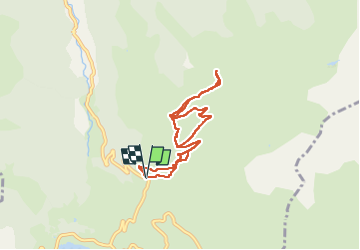

Length
7.6 km

Max alt
1638 m

Uphill gradient
434 m
Km-Effort
13.4 km

Min alt
1197 m

Downhill gradient
432 m
Boucle
Yes
Creation date :
2024-03-17 08:41:23.0
Updated on :
2024-03-17 15:16:22.067

FREE GPS app for hiking
 SityTrail
IGN / Geographical institutes
SityTrail Plus
The world is yours!
About
Trail of 7.6 km to be discovered at Occitania, Ariège, Le Port. This trail is proposed by lebarça.
Positioning
Country:
France
Region :
Occitania
Department/Province :
Ariège
Municipality :
Le Port
Location:
Unknown
Start:(Dec)
Start:(UTM)
368342 ; 4741712 (31T) N.
Comments